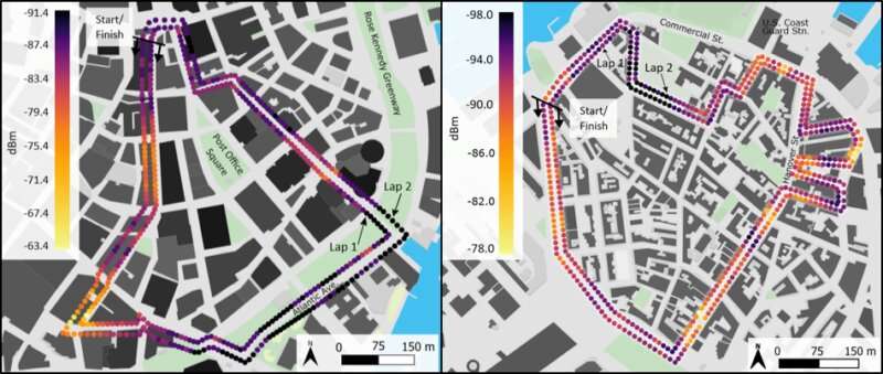
Maps show the median noise power along routes in downtown Boston (left) and North End (right). Lighter colors indicate higher amounts of noise. Credit: Breton et al. 2019
Researchers have created a street-level map of disruptive radio noise in Boston, they report in a new study. The study's findings suggest radio noise, which could obstruct first response or military communications, is persistent in urban environments and knowing its patterns could help make communications more reliable.
"Having a map of where highly intense noise regions are can help you understand why your communications aren't working," said Daniel Breton, a geophysicist at the U.S. Army Cold Regions Research and Engineering Laboratory in Hanover, New Hampshire and lead author of the new study in AGU's journal Radio Science.
"If you have that map and you're struggling with communications, wouldn't it be great to know 'I can move 50 meters down the street and be in the clear' or 'this particular neighborhood is notorious for noise sources, we need to get on a rooftop'?" Breton said.
Radio signals are broadcast through the air to send information to devices such as televisions, smartphones or satellite communication antennas. Unwanted noise from electrical switches or neon signs can interfere with these signals and delay critical alerts from reaching their destination.
The new study presents a map showing where such radio noise exists at street level in Boston, which could help ensure radios or satellite phones will operate in critical situations and let emergency response teams know what spots to avoid.
Few studies have characterized potential radio interference at such a small scale. Previous work relied on measurements from static locations or aircraft, which provided a fixed estimation of noise in a specific area, sometimes an entire city. But buildings, for example, can block some radio waves—or generate it themselves—and might influence where noise is found.
A survey from 1968 generated a map of radio noise using measurements from a truck while driving around San Antonio, Texas. The results suggested noise varied from street-to-street and was linked to cars, possibly from sparking ignitions.
But the electromagnetic environment has vastly changed since then, Breton said. Today, there may be different sources of radio noise and it's unclear how they are spread in the surrounding area.
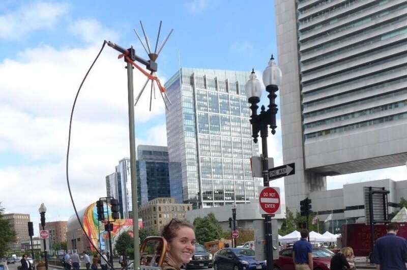
Caitlin Haedrich, a physical scientist at the U.S. Army Cold Regions Research and Engineering Laboratory, carried a 34-pound backpack containing radio wave monitoring equipment around the streets of Boston. Credit: Courtesy of Daniel Breton
A cumbersome backpack
In the new study, Breton and his colleagues wanted to pinpoint how far apart hotspots of radio noise are in modern urban environments. They measured background interference at one-meter (3.2-foot) intervals at three unused frequencies during business hours. These correspond to parts of the electromagnetic spectrum reserved for federal use and radio noise in this range could interfere with emergency communications.
Rather than riding in trucks to maneuver around the streets of Boston, the team got in their steps. They carried radio frequency-monitoring equipment in backpacks sporting a towering radio antenna, a recording device and an aluminum "radio-proof box" containing a laptop—a key feature to prevent the computer from contaminating their data. In total, the contraption weighed 15.4 kilograms (34 pounds).
"We definitely got some looks," said Caitlin Haedrich, a physical scientist at the U.S. Army Cold Regions Research and Engineering Laboratory and co-author of the study. "People clear the way for you on the sidewalk when you look like that."
With their radio frequency-monitoring backpacks, the researchers lapped around downtown Boston and the North End. These areas are packed with easy-to-divide neighborhoods that gave Breton, Haedrich and their team a chance to sample distinct zones, such as a street populated with skyscrapers or residential areas.
Part of the neighborhood
The group found radio noise signals varied significantly along Boston's streets. In downtown, for instance, noise power differed by more than a factor of 1000 between certain areas along the 2-kilometer (1.2 mile) route.
These signals also had repeatable patterns. Some were clustered in specific zones measuring from 20 to 100 meters (65 to 328 feet) long, while other spots had less interference.
Breton isn't sure what the sources of noise are—though light bulbs, laser printers or computer power supplies could be culprits—but they don't appear to move over time, he said.
Surprisingly, noise clusters were not associated with traffic, contrary to findings from the 1968 study in Texas. The team measured the lowest values for noise along heavily-trafficked Atlantic Avenue in downtown Boston, suggesting that buildings may provide the bulk of interfering radio waves.
"Noise is part of the neighborhood," Breton said. "There are certain corners you're going to walk by and there's going to be intense noise, which may impact a variety of systems."
Provided by American Geophysical Union
This story is republished courtesy of AGU Blogs (http://blogs.agu.org), a community of Earth and space science blogs, hosted by the American Geophysical Union. Read the original story here.


