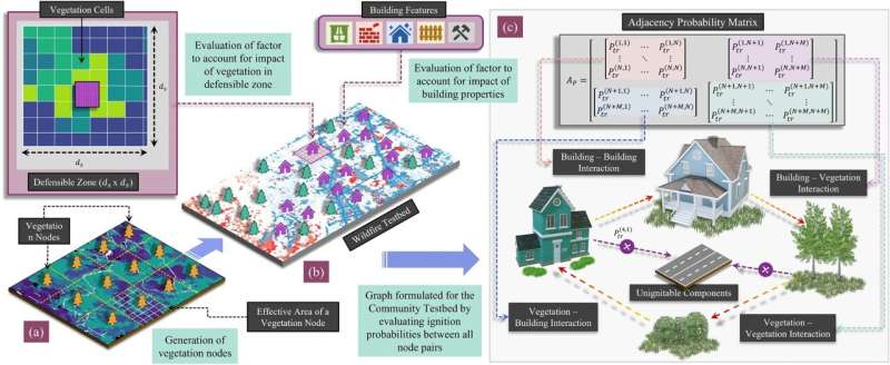
Framework for formulating a graph for a selected wildfire testbed to capture fire interactions between ignitable components within a community. (a) Vegetation nodes are formulated from a GIS fuel raster layer (b) Building nodes are established for each ignitable structure, and factors are evaluated to account for building properties and vegetation in the defensible zone corresponding to each building node. (c) Interactions between all ignitable components (building and vegetation nodes) are realized by formulating an adjacency matrix with edge weights corresponding to the probability of ignition from one node to another. Credit: Scientific Reports (2022). DOI: 10.1038/s41598-022-19875-1
Wildfires may seem unpredictable, leaving random ruin in their wake.
CSU engineers have developed a model that can predict how wildfire will impact a community down to which buildings will burn. They say predicting damage to the built environment is essential to developing fire mitigation strategies and steps for recovery.
For years, Hussam Mahmoud, a Civil and Environmental Engineering professor, and postdoctoral fellow Akshat Chulahwat have been working on a model to measure the vulnerability of communities to wildfire. Most wildfire mitigation studies have focused on modeling fire behavior in the wildland; Mahmoud and Chulahwat's model was the first to predict how a fire would progress through a community.
"We're able to predict the most probable path the fire will take and how vulnerable each home is relative to the neighboring homes," Mahmoud said. "We put a spin on the original model that allows us now to determine the level of damage in each building, whether the building will burn or survive."
Using data from Technosylva, a wildfire science and technology company, Mahmoud and Chulahwat tested their model on the 2018 Camp Fire and 2020 Glass Fire in California. The model predicted which buildings burned and which survived with 58-64% accuracy. Since publishing their results in Scientific Reports, they have predicted which buildings burned with 86% accuracy for the Camp Fire by adjusting how the model weighs certain factors that contribute to damage.
Mahmoud says a holistic approach is needed to understand wildfire behavior and bolster resilience. Models that incorporate a community's wildland and built environment features will give decision-makers the information needed to mitigate vulnerable areas.
Wildfire is like a disease
To develop their model, Mahmoud and Chulahwat employed graph theory, which is used to analyze networks. These methods also are used to study how diseases spread.
"Wildfire propagation in communities is similar to disease transmission in a social network," Mahmoud said. Fire spreads from object to object in the same way contagions pass from one person to another.
Wildfire mitigation strategies are like the tactics used to control the spread of COVID-19, he said. A community's immune system can be boosted by mapping a structure's surroundings (contact tracing), clearing defensible space around structures (social distancing), reinforcing structures to be more fire resistant (immunization), and creating a buffer zone at the wildland-urban interface (closing borders).
Some homes are like super-spreaders—they are more at risk of fire and more likely to transmit fire to other homes. By targeting certain homes or areas for reinforcement, policymakers could maximize a community's mitigation efforts, Mahmoud said.
As wildfire risk is compounded by more people moving to wildland-adjacent areas and climate change drying out the landscape in arid regions, the researchers hope their model will help protect communities from the devastating losses wrought by wildfires.
More information: Akshat Chulahwat et al, Integrated graph measures reveal survival likelihood for buildings in wildfire events, Scientific Reports (2022). DOI: 10.1038/s41598-022-19875-1
Journal information: Scientific Reports
Provided by Colorado State University


