Laser attack blinds autonomous vehicles, deleting pedestrians and confusing cars
Self-driving cars, like the human drivers that preceded them, need to see what's around them to avoid obstacles and drive safely.
Oct 31, 2022
4
266
Security

Self-driving cars, like the human drivers that preceded them, need to see what's around them to avoid obstacles and drive safely.
Oct 31, 2022
4
266
Engineering

Autonomous vehicles relying on light-based image sensors often struggle to see through blinding conditions, such as fog. But MIT researchers have developed a sub-terahertz-radiation receiving system that could help steer ...
Feb 14, 2019
2
41
Electronics & Semiconductors

When Google unveiled its first autonomous cars in 2010, the spinning cylinder mounted on the roofs really stood out. It was the vehicle's light detection and ranging (LiDAR) system, which worked like light-based radar. Together ...
Mar 9, 2022
0
308
Automotive

Lidar can be the third eye and an essential component for safe driving in your automated car's future. That is the word from Bosch. They want the world to know that two is not ideal company; three is better company. Cameras ...
Computer Sciences
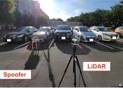
A University of California, Irvine-led research team has demonstrated the potentially hazardous vulnerabilities associated with the technology called LiDAR, or Light Detection and Ranging, many autonomous vehicles use to ...
Mar 1, 2024
1
47
Engineering

Standard image sensors, like the billion or so already installed in practically every smartphone in use today, capture light intensity and color. Relying on common, off-the-shelf sensor technology—known as CMOS—these ...
Mar 28, 2022
0
246
Engineering

During the EnRicH 2021 European Robotics Hackathon, Southwest Research Institute's unmanned aircraft system (UAS) explored and mapped the interior of a nuclear power plant, detecting radiation sources—autonomously without ...
Nov 18, 2021
0
12
Software

Pedestrian safety is critical to improving walkability in cities. To that end, NITC researchers have developed a system for collecting pedestrian behavior data using LiDAR sensors. Tested at two intersections in Texas and ...
Mar 13, 2023
0
31
Hi Tech & Innovation

A Seattle-based company is talking up a storm about solid state lidar powered by liquid crystal metasurface (LCM) technology. The company CTO is proclaiming the LCM chip as "the holy grail of LiDAR."
Automotive

Researchers at Duke University have demonstrated the first attack strategy that can fool industry-standard autonomous vehicle sensors into believing nearby objects are closer (or further) than they appear without being detected.
Mar 14, 2022
0
98
LIDAR (Light Detection And Ranging, also LADAR) is an optical remote sensing technology that can measure the distance to, or other properties of a target by illuminating the target with light, often using pulses from a laser. LIDAR technology has application in geomatics, archaeology, geography, geology, geomorphology, seismology, forestry, remote sensing and atmospheric physics, as well as in airborne laser swath mapping (ALSM), laser altimetry and LIDAR contour mapping.
The acronym LADAR (Laser Detection and Ranging) is often used in military contexts. The term "laser radar" is sometimes used, even though LIDAR does not employ microwaves or radio waves and therefore is not radar in the strict sense of the word.
This text uses material from Wikipedia, licensed under CC BY-SA