September 2, 2015 weblog
Info tool on weather-related road conditions aids driver safety
Now drivers can be better warned of potentially dangerous weather-related road conditions with a new product from INRIX.
INRIX Road Weather uses data from connected cars and weather predictions. Finding a better way to go is one benefit. Another, said the company, is helping cities make transportation networks work smarter. Public transportation and road maintenance agencies can be more efficient applying resources.
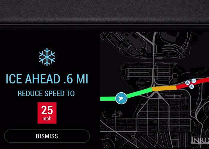
Jacob Demmitt in GeekWire quoted the company's CMO Steve Banfield: "It's about not just knowing it's cold out so there might be some slick roads. We can tell you exactly where you'll have standing water, black ice, fog."
Weather-related car fatalities and commercial losses add up to a level where a product of this nature would draw interest.
"Even when general weather conditions are bad," said Uri Lavee, core technology product manager at INRIX, "it is very hard to anticipate where exactly one would hit a patch of black ice or start hydroplaning. That is why 25 percent of US accidents and 30 percent in Europe are weather-related."
INRIX on Tuesday announced the INRIX Road Weather is now available, with updated alerts every 15 minutes. Drivers are told about the type of precipitation, surface conditions and visibility. The information comes from (1) public and private data sources, (2) vehicle sensor data, and (3) forecast modeling technology from Global Weather Corporation. The company has partnered with Global Weather Corporation (GWC) for its expertise in predicting weather's effects on road surfaces.
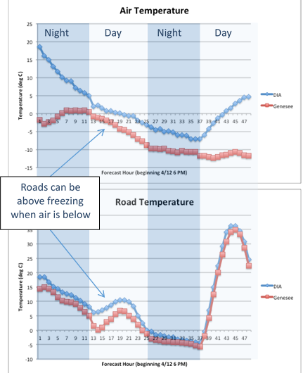
Lavee pointed out that traditional weather forecast algorithms are focused on predicting general atmospheric conditions rather than the meteorological situation of the road surface itself. He said, "although these things are connected, they may be quite different at times."
Lavee remarked that In some places (e.g. Germany, Austria, some highways in the US) road authorities attempt more granular measurements by positioning sophisticated weather sensors along roadways: Road Weather Information Systems, or RWIS stations. "These sensors can be expensive to install and maintain," he said, "so coverage is often limited to select set of highways."
GWC uses what Lavee called "a unique set" of prediction algorithms to accurately predict temperature and precipitation on the road. "Global Weather Corporation has pioneered the global use of hyperlocal weather models to create forecasts even specific enough for vehicle applications," said Mark Flolid, GWC CEO.
As for the connected vehicle itself as a data source, Lavee called out advantages. "A good portion of cars from which we are leveraging anonymous GPS data as the basis for our traffic information are also equipped with advanced sensors that can provide weather-related measurements such as ambient external temperature or barometric pressure. These measurements are by their nature closer to the road surface and provide both high temporal and spatial resolution in comparison to existing weather stations."
He noted a single vehicle could cover miles of roadway in one hour. It could result in forecast algorithms with "hyper-granular input" that would lead to more accurate, hyper-local and frequent forecasts.
© 2015 Tech Xplore


