This article has been reviewed according to Science X's editorial process and policies. Editors have highlighted the following attributes while ensuring the content's credibility:
fact-checked
trusted source
proofread
Studying flight paths and neighborhoods could lead to more considerate aviation

When aerospace engineer Matthew Clarke overlayed flight paths in urban environments over maps showing social stratification, he noticed something significant. The flights went directly overhead low-income neighborhoods.
"I learned about a group in Palo Alto who wanted to divert the flight path of aircraft flying from San Francisco airport over Stanford to flying over East Palo Alto—a predominately Black and Latinx community," Clarke said. "The group from Palo Alto were trying to get the FAA to shift that flight path and the FAA said it needs to be done equitably. We can't have all the noise going over one neighborhood."
Clarke, who is an assistant professor in the Department of Aerospace Engineering at the University of Illinois Urbana-Champaign, said a similar situation is observable In Los Angeles.
"If you look at the LAX airport, the flightpath is just above Compton and Inglewood, which are also low-income neighborhoods."
To address the issue, Clarke said he didn't want to just model aircraft noise, which has already been done well.
"I wanted to map an urban environment, so I strategically chose flight paths that are of special interest, for example, Los Angeles to Disney, because there are communities between LAX and Disney that are going to be affected. The study looks at not only the aircraft in terms of performance, but also the impact of aircrafts' noise footprint on the ground."
Clarke's findings are published in the journal AIAA AVIATION 2023 Forum.

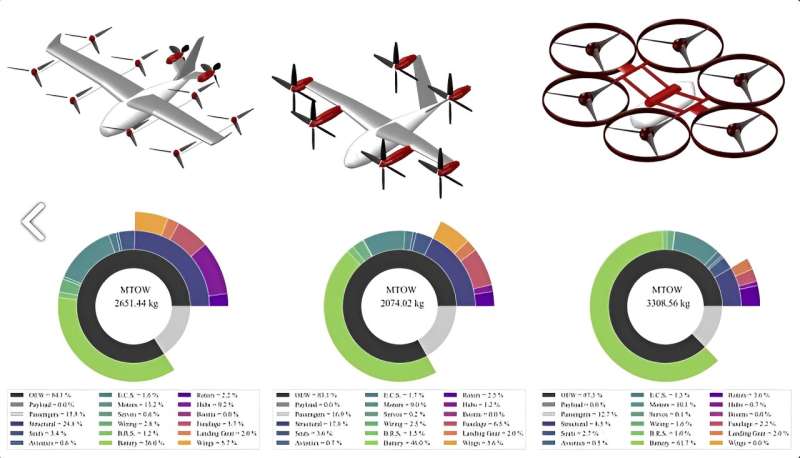
Because the concerns about noise will likely increase as commuting and delivery services ramp up the use of drones and other uncrewed aircraft in urban settings, Clarke compared the noise emissions from low altitude aircraft to that of cars in three case studies using three types of electric vertical take-off and landing vehicles, or EVTOLs, that are popular with aircraft design companies: stopped-rotor aircraft, tilt-rotor aircraft, and a hexacopter.
The first study examined fly-over noise, the second explored vertiport arrival and departure flight path angles, and the third examined noise emissions within the Los Angeles Metropolitan area.
Clarke said models of both highway noise and aircraft noise already exist. He plotted them on a graph to demonstrate the noise levels in relationship to the distance from the highways. The noise levels were computed by not just the loudness but also the frequency of how many times it can be heard over a specific time period.
"The results identify the hexacopter as creating the most significant noise and it is a lot louder than the highway noise, so it's going to be noticeable. However, for the other two aircraft, the highway noise is more dominant. So, if you fly over highways, you can mask the noise of these new aircraft and they won't be a disturbance."
By understanding the noise footprint, Clarke said hot spots in the Los Angeles area can be identified.
"Where I hope to go with this research is to help inform an FAA noise compatibility program. It is basically a map of each city and identifies noise-sensitive features such as schools, hospitals, universities, churches—the sorts of areas aircraft need to avoid. I want to overlay a noise feature map with the routes of these aircraft and see how the paths can change to avoid these sensitive areas. It's an effort to be more considerate of those who live near airports or in the path of aircraft."
Clarke said he'd like to work with social scientists to take it further. The noise affects people, but it can also affect wildlife and their ability to locate mates and predators.
"If we can reduce or change the noise spectrum to reduce human impact, we'll also benefit animals—maybe not in the Los Angeles area, but for other cities that have a larger population of wildlife. These are very important things that I think we need to pay more attention to before we think about putting vertiports and helipads and EVTOLs everywhere. We need to think about the broader impact of aviation."
More information: Matthew A. Clarke, An Open-Source Framework For Modeling Aircraft Noise In Urban Environments, AIAA AVIATION 2023 Forum (2023). DOI: 10.2514/6.2023-3365


