This article has been reviewed according to Science X's editorial process and policies. Editors have highlighted the following attributes while ensuring the content's credibility:
fact-checked
trusted source
proofread
Bridging the urban canyons: 5G's role in advanced real-time kinematic positioning

High-precision positioning in urban areas faces obstacles such as frequent signal blockages and interference from buildings, which compromise the performance of Global Navigation Satellite System (GNSS)-based Real-Time Kinematic (RTK) systems. These conditions lead to reduced accuracy and reliability, making it difficult for traditional solutions to meet precision demands.
While past attempts have utilized technologies like Wi-Fi and Bluetooth, 5G's enhanced speed, bandwidth and deployment density present a more viable solution. Addressing these challenges is essential for advancing positioning technologies in complex urban settings.
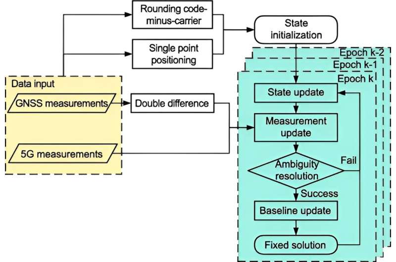
Researchers from Tsinghua University have introduced an innovative 5G-assisted BeiDou Navigation Satellite System (BDS) RTK positioning system, as published on August 26, 2024, in Satellite Navigation. The system employs an extended Kalman filter and advanced ambiguity resolution techniques, merging 5G observations with conventional satellite data. This novel approach significantly improves positioning accuracy in urban environments, demonstrating its potential to revolutionize high-precision positioning for various applications in complex city landscapes.
The study assessed the impact of 5G integration on BDS RTK positioning using gain factors to evaluate float solution and ambiguity dilution of precision (ADOP). The 5G-enhanced system showed substantial accuracy improvements, reducing spatial errors by 48% in full ambiguity resolution (FAR) mode and 18.8% in Partial Ambiguity Resolution (PAR) mode.
Fixing rates increased from 11.11% to 13.93% in FAR mode and from 32.58% to 44.43% in PAR mode. These results indicate that 5G effectively counters urban signal obstructions, boosting overall positioning performance and providing a robust solution for high-precision needs in challenging urban settings.
Dr. Tengfei Wang from Tsinghua University commented, "Integrating 5G technology with BDS RTK positioning tackles long-standing urban challenges, enhancing signal quality and boosting satellite visibility. This approach not only addresses positioning issues but also sets the stage for more reliable and accurate urban navigation solutions, especially in environments where traditional methods struggle."
The integration of 5G with BDS RTK has broad applications, enhancing positioning for autonomous vehicles, public safety, and smart city initiatives. With 5G networks already widely deployed, this system offers a scalable and adaptable solution for improving location-based services in urban areas.
Future research will further test its performance in varied real-world scenarios, refining the integration to achieve even higher accuracy and reliability in urban positioning.
More information: Weixiang Chen et al, Analysis of the gain factors of 5G-assisted BDS RTK positioning in urban environments, Satellite Navigation (2024). DOI: 10.1186/s43020-024-00149-2


