Autonomous vehicle technology vulnerable to road object spoofing and vanishing attacks
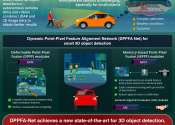
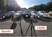
A University of California, Irvine-led research team has demonstrated the potentially hazardous vulnerabilities associated with the technology called LiDAR, or Light Detection and Ranging, many autonomous vehicles use to ...
Mar 1, 2024
1
47